| |
Blackburn is administered by Blackburn with Darwen unitary authority, which encompasses Blackburn and the small town of Darwen to the south. The town sends one Member of Parliament (MP) to the House of Commons.
[edit] Local government
-
The council has been elected 'by thirds' since 1996, with one councillor from each of the three-member wards being elected every year, with those representing 2-member wards being elected in alternative years. Every four years there is a year with no elections, the next such period being 2009.
In their 2007 Comprehensive Performance Assessment (CPA), the Audit Commission described the council as "improving well" and gave it their highest "four star" overall performance rating. Although children’s services, adult social care and GCSE results were praised, the Commission did highlight "significant health problems" and increased "levels of repeat victims of domestic violence" as causes for concern.[42] Despite generally good performance, overall user satisfaction levels with the Council are below average and not improving.[42] The borough was awarded Beacon Council status and shares its best practice in education policy with other councils as part of the scheme.
[edit] Parliamentary representation
The historic constituency of Blackburn was created for the 1832 general election and sent two MPs to Westminster. It was abolished in 1950 and replaced for one parliamentary term by two new single-member constituencies, Blackburn East and Blackburn West. At the 1955 general election, Blackburn East and Blackburn West were merged into the modern-day constituency, returning a single MP.
[edit] Coat of arms
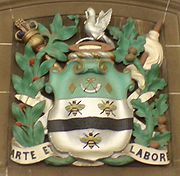
Arms of the former Blackburn Borough Council on display in the town hall.
The coat of arms of the former Blackburn Borough Council has many distinctive emblems.[43] The arms displays Argent a Fesse wavy Sable between three Bees volant proper on a Chief Vert a Bugle stringed Argent between two Fusils Or. On the crest, a Wreath of the Colours a Shuttle Or thereon a Dove wings elevated Argent and holding in the beak the Thread of the Shuttle reflexed over the back and an Olive Branch proper. The latin motto of the town is 'Arte et Labore', correctly translated as 'by art and by labour' but often translated as 'by skill and hardwork'. The motto, granted on 14 February 1852 to the former Borough of Blackburn, is poignant as Blackburn, once a small town, had risen to importance through the energy and enterprise of her spinners and manufacturers, combined with the skill and labour of her operatives. The Borough of Blackburn was formed by the amalgamation of the County Borough of Blackburn, the Borough of Darwen, part of the Turton Urban District and the parishes of Yate and Pickup Bank, Eccleshill, Livesey, Pleasington and Tockholes from the Blackburn Rural District. Other notable features include:
- Three bees in flight. The bee is an emblem of skill, perseverance and industry and "B" also stands for Blackburn.[43] Furthermore, as the Peel family sprang from this neighbourhood and bears a bee in flight on its shield, the idea naturally suggests itself that Sir Robert Peel had adopted the Blackburn bee.
- The shield is silver or white, and thus emblematical of calico, the product of the Blackburn bees during the industrial revolution.[43]
- The broad wavy black line represents the Black Brook (the River Blakewater) on the banks of which the town is built.[43]
- The silver bugle horn was the crest of the first Mayor of Blackburn, William Henry Hornby. It is also an emblem of strength.[43]
- The gold lozenges, or fusils (diamond shaped), are the heraldic emblems of spinning, derived from the Latin "fusus" or "fusilium", meaning a spindle, and they refer to the invention of the spinning jenny in 1764 by James Hargreaves, a native of the district.[43] They also denote the connection of Joseph Feilden with Blackburn, as Lord of the Manor, as he bore lozenges on his shield.
- The background of green alludes to the Blackburn was one of the royal forests in the time of Edward the Confessor.[43]
- The shuttle is the emblem of weaving, the trade which has contributed more than any other to the prosperity of the town.[43]
- The dove taking wing with an olive branch in her beak (the emblem of peace) attached to the thread of the shuttle, represents the beneficial results emanating from the art of weaving.[43]
[edit] Politics
Blackburn council and its successor have been predominantly controlled by the Labour Party since 1945 and continuously for 24 years until May 2007 when it fell into no overall control.[44] UKPollingReport characterises the constituency of Blackburn as "a mix of deprived inner-city wards dominated by Muslim voters, white working class areas and Conservative voting suburbs".[45] The sitting MP is current Secretary of State for Justice and former Foreign Secretary, Jack Straw. Previous MPs for Blackburn include former Labour cabinet minister Barbara Castle, who represented the town in Westminster from 1945 to 1979.
[edit] The far right
Around 20% of Blackburn's population come from ethnic minorities and in recent years the town has witnessed a resurgence in the fortunes of far-right political parties in local elections. The council until recently had two members for the England First party, Mark Cotterill for Meadowhead ward and Michael Johnson for Fernhurst. Mark Cotterill has since stood down and Michael Johnson joined the For Darwen party. Members of the British National Party (BNP) have previously won a council seat in the town in November 2002 following elections in May which saw three of their colleagues elected in nearby Burnley. The BNP's Robin Evans secured a 16-vote majority in Mill Hill ward with two recounts following a campaign using pub meetings and leafleting.[46] The incumbent Liberal Democrats were pushed into third place behind Labour. Although plans had been blocked by the time of the poll, proposals to convert a nursing home in the ward into a centre for asylum seekers were seen as a key election issue.[47] Developments in Burnley and Blackburn were regarded as something of a renaissance for the far right in British politics, no such councillors had been elected in the UK since victories in Tower Hamlets nearly ten years before.[48]
Commenting on the elections, Blackburn MP Jack Straw said: "It is very sad. We had the far right in Blackburn 26 years ago when they won two seats in Shadsworth. But there the whole community decided they wouldn't have it. You can never say they won't put candidates in Blackburn but we will work hard on community relations."[49] Blackburn had two council members from the National Party in the 1970s. Although some towns in the North of England suffered race riots in the summer of 2001, the streets of Blackburn remained quiet.
[edit] Other political events
In October 2006, comments made by Jack Straw angered some in the Muslim community. Writing in the Lancashire Telegraph, the MP said that Muslim women who wear full veils make "better, positive relations" between communities more difficult and that failing to show the mouth and nose was "a visible statement of separation and of difference."[50][51]
[edit] Geography
| Climate chart for Blackburn |
| J |
F |
M |
A |
M |
J |
J |
A |
S |
O |
N |
D |
|
|
|
|
|
|
|
|
|
|
|
|
|
temperatures in °C • precipitation totals in mm
source: Records and averages. Yahoo! Weather (2007). |
Imperial conversion
| J |
F |
M |
A |
M |
J |
J |
A |
S |
O |
N |
D |
|
|
|
|
|
|
|
|
|
|
|
|
|
| temperatures in °F • precipitation totals in inches |
|
At 54°44'41?N, 2°28'37?W (53.7449°, -2.4769°), and 184 miles (296 km) north-northwest of London, Blackburn stands 401 feet (122 m) above sea level, 8.9 miles (14.3 km) east of Preston and 20 miles (32.2 km) north-northeast of Manchester. The Ribble Valley and West Pennine Moors lie to the north and south respectively. Blackburn experiences a temperate maritime climate, like much of the British Isles, with relatively cool summers and mild winters. There is regular but generally light precipitation throughout the year.
Although the city of Preston, the administrative centre for the county, is located around 9.2 miles (14.8 km) to the west, Blackburn is the largest municipality in what is known as East Lancashire. The town is bounded on other sides by smaller towns, including Accrington to the east and Darwen to the south. Blackburn and Darwen together make up Blackburn with Darwen unitary authority. Around 2.5 miles (4.0 km) to the north of the town centre, is the village/suburb of Wilpshire, with the village of Langho approximately 1.2 miles (1.9 km) further to the north west. A number of even smaller localities are sometimes considered extended suburbs of Blackburn, including Rishton to the east, Great Harwood to the north east and Mellor to the north west. Rishton, Great Harwood and Accrington are part of the local government district of Hyndburn. 11 miles (18 km) further to the east lies the town of Burnley[52]
Blackburn is served by a newly redeveloped train station located in the town centre next to the bus station and served by Northern Rail. The nearest train station on the West Coast Main Line is Preston.
[edit] Geology and terrain

View north over Lammack and Pleckgate from one of the highest points in Blackburn at the site of the old water tank at Revidge (click to enlarge).
Located in the midst of the East Lancashire Hills, some areas of the town are characterised by steep slopes. The town centre is located in a depression surrounded by a number of hills. The area of Revidge to the north can be reached via a steep climb up Montague Street and Dukes Brow to reach a peak of 715 feet (218 m) above sea level. To the west, the wooded Billinge Hill in Witton Country Park is 804 feet (245 m) high, while Royal Blackburn Hospital is situated to the east of the town at a vantage point of 663 feet (202 m).[53] These figures can be considered in the context of other hills and mountains in Lancashire, including Great Hill at 1,496 feet (456 m), Winter Hill at 1,496 feet (456 m), Pendle Hill at 1,827 feet (557 m) and Green Hill 2,060 feet (628 m).
The River Blakewater, which gives its names to the town, flows down from the moors above Guide and then through the areas of Whitebirk, Little Harwood, Cob Wall and Brookhouse to the town centre. The river was culverted during the industrial revolution and runs underground in the town centre, under Ainsworth Street and between Blackburn Cathedral and Blackburn Bus Station. On the western side of the town centre the Blakewater continues under Whalley Banks and through the Redlam area before joining the River Darwen outside Witton Country Park and continuing on to join the River Ribble at Walton-le-Dale.

Sketch of coal mining equipment on Coalpit Moor, formerly known as Blackburn Moor, from 1846.
The geology of the Blackburn area yields numerous resources which underpinned its development as a centre of manufacturing during the Industrial Revolution. Mineable coal seams have been used since the mid-late 16th century.[54] The coal measures in the area lie on a bed of millstone grit, which has been quarried in the past for millstones and, along with local limestone deposits, used as a construction material for roads and buildings. In addition, there were deposits of iron ore in the Furness and Ulverston districts.[55] The Blackburn area was subjected to glaciation during the Pleistocene ice age, and the sandstone-and-shale bedrock is overlain in much of the area by glacial deposits called till (which is also called "boulder clay") of varying thickness up to several tens of feet. Glacial outwash (sand and gravel) also occur in small patches, including along Grimshaw Brook.[56][57][58]
[edit] Demography

Blackburn and the southern town of Darwen as viewed from space by the Landsat 7 satellite (false colour image).
According to the UK Government's 2001 census, Blackburn, defined as an urban area, had a population of 105,085 and a population density of 11,114/sq mi (4,291/km²).[1] According to further statistics from the same census, this time defining Blackburn as a Westminster parliamentary constituency, the town was 69.22% White British (national average for England 89.99%) with significant Indian (14.31%) and Pakistani (11.45%) ethnic minorities.[59] 12.33% of the population was born outside the European Union.[60] In terms of religion, 57.53% of residents were Christian (average for England 71.74%), 25.74% Muslim (average for England 3.1%) and 15.98% no religion or not stated.[61]
With regard to the economic activity of those aged 16-74, the 2001 Census indicates that 33.93% were full-time employees (average for England 40.81%), 11.72% were part-time employees, 5.97% were self-employed (average for England 8.32%), and 4.5% were unemployed (average for England 3.35%).[62]
The 2001 census also records the social grade of the constituency's 72,418 people aged 16 and over. Using the NRS social grades system, 10,748 were classed as AB (higher and intermediate managerial / administrative / professional), 17,514 as C1 (supervisory, clerical, junior managerial / administrative / professional), 11,691 as C2 (skilled manual workers), 19,212 as D (semi-skilled and unskilled manual workers), and 13,253 as E (on state benefit, unemployed, lowest grade workers).[63]
[edit] Economy
The town centre is currently subject to a new multi-million pound investment, and Blackburn with Darwen Council have already made some refurbishments and renovations of key public places, notably the Church Street area with its Grade II listed[64] art deco Waterloo Pavilions complemented by street furniture and sculptures.
The Mall Blackburn (formerly known as Blackburn Shopping Centre) is the main shopping centre in Blackburn with over 130 shops and 400 further outlets close by.[65] Blackburn Markets are situated opposite the mall on its Ainsworth Street side. First opened in 1964, they are comprised of a 3-day market (Wednesday, Friday, Saturday) and the Market Hall (Monday-Saturday). The town centre was expanded by construction of the Grimshaw Park retail development (including Blackburn Arena) in the 1990s. The adjacent Townsmoor Retail Park and Peel Leisure and Retail Park are more recent developments.
The markets continue to offer a wide range of local produce - Lancashire cheeses, tripe, Bowland beef and lamb can all be found. There is also Walsh's Sarsaparilla stall. The markets are expected to move into the Mall shopping centre in 2010, and to open six days a week.[66]
Major employers in Blackburn include: BAE Systems (Samlesbury site, located at Balderstone, northwest of Blackburn); Blackburn with Darwen Borough Council; and the East Lancashire Hospitals NHS Trust (Based at the Royal Blackburn Hospital).
[edit] Cultural references
Those familiar with the work of the The Beatles may recognise Blackburn as the town mentioned in the song "A Day in the Life". An article in the Daily Mail about a plan to fill potholes in the town caught John Lennon's eye as he was writing the song, giving birth to the lyric: "I read the news today. Oh, boy. 4,000 holes in Blackburn, Lancashire." [67] The title of the unofficial fanzine of the town's football club, Blackburn Rovers, is 4,000 Holes.
The 2005 British film Love + Hate, directed by Dominic Savage, was shot in Blackburn.[68][69]
[edit] Landmarks
[edit] Cathedral
Blackburn Cathedral was formerly Saint Mary's Parish Church. When Saint Mary's was consecrated, in 1826, it is believed a church had already stood on the site for several hundred years. In 1926 the Diocese of Blackburn was created and the church gained cathedral status.[70] Between the 1930s and 1960s an enlarged cathedral was built using the existing building as the nave.[71] Six of the cathedral's bells were cast in 1737 and are claimed to have been cast from even older bells.[72] An image of the Cathedral is used behind BBC interviews held in Blackburn, which are filmed at BBC Radio Lancashire on Darwen Street, opposite the Cathedral.
[edit] Town hall
The construction of Blackburn's original, Italian renaissance style town hall was completed in 1856 at a cost of £35,000.[73]. A tower block extension was constructed over a century later, in 1969, at a cost of £650,000 (the tower block is not strictly an extension to the earlier building: the two buildings are connected only by an elevated, enclosed footbridge). The tower block was 198 feet (60 m) high and the top was 545 feet (166 m) 9 inches (23 cm) above sea-level when built[74], though it has since been re-clad and these figures may have altered slightly.

Blackburn's 19th century Technical School
[edit] Technical school
The foundation stone of the Technical School building was laid on the 9th of May 1888 by the Prince and Princess of Wales; the building was completed towards the end of 1894. It is built in the northern rennaissance style and has a slate roof, an attic, a basement, and two intermediate storeys. Made mainly of red brick and yellow terracotta, it is profusely decorated and features ornate gables, a round arched entrance with angle turrets and balcony above, and a frieze below the top storey with panels depicting art and craft skills. The Technical School is a grade II listed building and is now part of Blackburn College.[75][76][77]

Blackburn's Statue of Queen Victoria with the cathedral in the background
[edit] Statue of Queen Victoria
Blackburn's statue of Queen Victoria is located next to the cathedral grounds overlooking the bus station. Victoria's fourth daughter, Princess Louise, Duchess of Argyll, unveiled the statue on September 30, 1905. It was sculpted by Australian sculptor Sir Bertram McKennal out of white Sicilian marble and stands on a grey granite plinth.[78] The statue is 11 feet (3.4 m) high and weighs 9 long tons (9.1 t), while the plinth is 14 feet (4.3 m) high and weighs 30 long tons (30.5 t).[79]
[edit] Ewood Park

Ewood Park's Jack Walker stand.
-
Ewood Park stadium has been the home of Blackburn Rovers football club since they moved there from Leamington Road in 1890. The ground was officially opened on the 13th of September that year.[80] Work on the current, redeveloped, all-seater stadium got underway in February 1993 when the old Darwen End stand was demolished. This stand, together with the old Blackburn End stand, was then redeveloped before the Nuttall Street stand was also demolished ready for redevelopment in January 1994. Almost two years later, on the 18th November 1995, the newly redeveloped Ewood Park was officially opened.[81] With a capacity of 31,367,[82] the facility currently comprises four sections: the Darwen End, Riverside Stand (named as such because it stands practically on the banks of the River Darwen), Blackburn End, and Jack Walker Stand, which is named after Blackburn industrialist and club supporter, Jack Walker. The stadium also houses conference and banqueting facilities.[83]
[edit] Other landmarks
A £10million bridge is currently under construction on Freckleton Street. The bowstring arch bridge crosses the East Lancashire and Ribble Valley railway lines west of the town centre and forms part of the A6078 Town Centre Orbital Route. The bridge will be completed in summer 2008 and is to be named after Alfred Wainwright following a vote by the townspeople.[84][85]

King George's Hall, Blackburn
Blackburn Arena, which houses an ice rink and is home to the Blackburn Hawks ice hockey team, opened in 1991.
Blackburn Railway Station features a 24 foot (7.3 m) mural by Stephen Charnock, which depicts eight famous faces associated with the town, including Mohandas Gandhi, who visited nearby Darwen in 1931. The station was renovated in 2000. BBC Radio Lancashire has its studios on Darwen Street in the town centre. Thwaites Brewery which produces cask ale has had a position in the centre of the town since 1870. There is also King George's Hall, which is an arts and entertainment centre, and Thwaites Empire Theatre.
A notable green space is Corporation Park which opened in 1856. A section of the Leeds and Liverpool Canal runs through the town. Witton Country Park is a 480 acres (1.9 km²) space to the west of the town.
[edit] Education
- See List of schools in Blackburn
Over £25 million is currently being invested in education initiatives including new schools, city learning centres, children's centres and an Academy in Darwen in partnership with the Rodney Aldridge Trust. Over 11,000 adults are in some form of educational programme.[86] Blackburn with Darwen council have twice had Beacon Status for education in the 'Fostering School Improvement' and 'Transforming the School Workforce' categories.[86]
51.3% of pupils achieve grades A*-C in Blackburn with Darwen compared with 56.5% nationally.[87] The average GCE/VCE A/AS and Equivalent Point Score per Student is 649.7 compared with 716.7 nationally.[87]
Tauheedul Islam Girls' High School, in Blackburn, became the first Muslim state school in the North West. It was originally independent but its status changed in 2005.[88] It has been a success in school league tables, with a high score for contextual value added.[89] Although the town's ethnic minority population is below 25%, in some schools the vast majority of pupils are from the ethnic minority population, whilst other schools are almost entirely white, and this segregation has been identified as a problem for racial integration within the town.[90]
Independent school sector is represented in the town by Queen Elizabeth's Grammar School (QEGS) and Westholme School. East Lancashire Institute of Higher Education (ELIHE) is for degree students over the age of 18. St Thomas's and Sunnyhurst Pupil Referral Unit educates children who are unable to attend mainstream school for health reasons or other difficulties.[91] There are plans being developed for a university campus in the town.[92]
[edit] Sports
[edit] Blackburn Rovers and Football
-
Premier League Football side Blackburn Rovers is based at the Ewood Park stadium. The club has done much to raise the profile of the town, winning the Premier League in 1995 and the League Cup in 2002. The club was established in 1875, and in 1888 became a founder member of The Football League. In 1890 Rovers moved to its permanent home at Ewood Park. Until the formation of the Premier League in 1992, the majority of Blackburn Rovers' success was pre-1930 when they won the league twice and FA Cup six times.[93] Blackburn has had a particular strong history of football. Rovers weren't the town's only side in the 19th century; rivals included Blackburn Olympic F.C. (1883 winners of the FA Cup) and Blackburn Park Road F.C., amongst others.
In January 1991 Jack Walker, a life-long supporter who built a business from humble beginnings in Blackburn, eventually making millions in the steel industry, took control of the club.[94] He lured former Liverpool legend Kenny Dalglish as manager and a number of player purchases followed, helping the club to gain promotion back into the first division, just before it became the F.A. Premier League, at the end of the 1991/1992 season.[95] Blackburn is one of only a handful of clubs to be founders of both the Football League and the Premier League. In the summer of 1992 the club set a new British transfer record with the purchase of Alan Shearer for £3.3 million.[96] After finishing runners-up to Manchester United in 1993/1994, Rovers won the championship the following year.[97] A slump followed in the late 1990s, with relegation to League Division One. In 2001, the team secured promotion back into the Premier League, and in 2002 won the League Cup.[98]
[edit] Notable people
People, involved in the arts, born in the town include: the actress Kathleen Harrison in 1892[99]; the author of the Pictorial Guides to the Lakeland Fells Alfred Wainwright in 1907; broadcaster Russell Harty in 1934; the writer Josephine Cox in 1941 who set many of her novels in Lancashire; the actor Anthony Valentine in 1939; the actor Michael Billington, star of UFO in 1941; actor Ian McShane in 1942[100]; actor Jon Walmsley in 1956; film maker Michael Winterbottom in 1961[101]; actor Steve Pemberton in 1967[102]; actress Wendi Peters in 1968; actor/comedian Lee Mack in 1968; and TV presenter and documentary director Michael Gibson (TV presenter) in 1980.
Notable sports personalities born in Blackburn include: rock climber John Sumner in 1936[103]; and England rugby union player Will Greenwood in 1972. Additionally the motor racing engine designer Keith Duckworth was born here in 1933.
In the political arena, John Morley, 1st Viscount Morley of Blackburn, OM, PC, Liberal statesman, writer and newspaper editor was born in the town in 1838. The town is also closely linked to Barbara Castle who was an MP in Blackburn for 34 years (1945-1979) as well as holding the positions of Secretary of State for Employment and Productivity, First Secretary of State and Secretary of State for Social Services during the Labour governments of the sixties and seventies.
[edit] References
- , a b c d KS01 Usual resident population: Census 2001, Key Statistics for urban areas, Office for National Statistics
- , Census 2001: Blackburn with Darwen Local Authority, Office for National Statistics. Retrieved on 28 March 2008.
- , European regional development funding, Blackburn with Darwen Council, accessed 17 April 2008
- , Rare Treasure Found. Lancashire Evening Telegraph. Newsquest Media Group (1996-03-27). Retrieved on 2008-03-03.
- , Lancashire Historic Town Survey: Blackburn: Historic Town Assessment Report. Lancashire County Council (April 2005). Retrieved on 2008-03-03.
- , Lancashire County Council (2005), Lancashire Historic Town Survey: Blackburn, p. 16.
- , George C. Miller, Blackburn - the Evolution of a Cotton Town, p.4.
- , Site of All Hallows Spring-Holy well, Archaeology Data Service. Retrieved 31 January 2007.
- , Lancashire County Council (2005), Lancashire Historic Town Survey: Blackburn, p. 16.
- , Church of St. Mary the Virgin, Archaeology Data Service. Retrieved 31 January 2007.
- , Lancashire County Council (2005), Lancashire Historic Town Survey: Blackburn, p. 17.
- , Lancashire County Council (2005), Lancashire Historic Town Survey: Blackburn, p. 17.
- , Lancashire County Council (2005), Lancashire Historic Town Survey: Blackburn, p. 17.
- , Market Cross, Archaeological Data Society. Retrieved 31 January 2007.
- , Lancashire County Council (2005), Lancashire Historic Town Survey: Blackburn, p. 17.
- , Beattie, D. (1992). Blackburn:The Development of a Lancashire Cotton Town. Ryburn Publishing Limited. p 13.
- , Beattie, D. (1992). Blackburn:The Development of a Lancashire Cotton Town. Ryburn Publishing Limited. p. 49
- , Vision of Britain: Bartholomew Gazetteer Entry for Blackburn, A Vision of Britain through Time, Retrieved April 21, 2008.
- , Beattie, D. (1992). Blackburn:The Development of a Lancashire Cotton Town. Ryburn Publishing Limited. p. 15-16.
- , Beattie, D. (1992). Blackburn:The Development of a Lancashire Cotton Town. Ryburn Publishing Limited. p. 16-18.
- , Timmins, G. (1993). Blackburn: A Pictorial History. Phillimore and Co Ltd.
- , Beattie, D. (1992). Blackburn:The Development of a Lancashire Cotton Town. Ryburn Publishing Limited. p. 17
- , Turner, W. (1992). RIOT!: The Story of the East Lancashire Loom-Breakers in 1826. Lancashire County Books. p. 9
- , Turner, W. (1992). RIOT!: The Story of the East Lancashire Loom-Breakers in 1826. Lancashire County Books. p. 12
- , Turner, W. (1992). RIOT!: The Story of the East Lancashire Loom-Breakers in 1826. Lancashire County Books. p. 18-24
- , Taylor, A. (2000). 20th Century Blackburn. Wharncliffe Books. p. 11.
- , Taylor, A. (2000). 20th Century Blackburn. Wharncliffe Books. p. 18.
- , Taylor, A. (2000). 20th Century Blackburn. Wharncliffe Books. p. 24.
- , a b Taylor, A. (2000). 20th Century Blackburn. Wharncliffe Books. p. 109-110.
- , a b c d e f Taylor, A. (2000). 20th Century Blackburn. Wharncliffe Books. p. 47-55.
- , Indian Duties. www.cottontown.org. Retrieved on 19 May 2008.
- , Financial Crisis. www.cottontown.org. Retrieved on 19 May 2008.
- , Post-War Boom. www.cottontown.org. Retrieved on 19 May 2008.
- , Taylor, A. (2000). 20th Century Blackburn. Wharncliffe Books. p. 83.
- , a b 1950s Decline. www.cottontown.org. Retrieved on 19 May 2008.
- , Taylor, A. (2000). 20th Century Blackburn. Wharncliffe Books. p. 87.
- , Taylor, A. (2000). 20th Century Blackburn. Wharncliffe Books. p. 91.
- , Taylor, A. (2000). 20th Century Blackburn. Wharncliffe Books. p. 94.
- , Local Decline. www.cottontown.org. Retrieved on 19 May 2008.
- , The End of an Industry. www.cottontown.org. Retrieved on 19 May 2008.
- , 20th Century Changes: Production and Decline. www.cottontown.org. Retrieved on 19 May 2008.
- , a b Blackburn with Darwen Borough Council Comprehensive Performance Assessment (CPA) scorecard, Audit Commission, 2007
- , a b c d e f g h i The Crests of Blackburn and Darwen, Blackburn with Darwen Council, accessed 16 April 2008
- , Shocked Labour loses control of Blackburn with Darwen, David Bartlett, Lancashire Telegraph, 4 May 2007
- , Blackburn Election Guide, UKPollingReport, retrieved 12 April 2008
- , BNP snatches council seat in Straw constituency, David Ward, The Guardian, 23 November 2002
- , Straw condemns BNP after victory in his backyard, Graeme Wilson, Adam Powell, Daily Mail, 23 November 2002
- , "BNP wins seat on East End council after recount", Mary Braid and Nick Walker, The Independent, 17 September 1993
- , BNP secures three seats, UK Newsquest Regional Press, David Higgerson, 27 November 2002
- , Straw in plea to Muslim women: Take off your veils, David Bartlett, Lancashire Telegraph, 5 October 2006
- , Straw asks women for veil rethink, 5 October 2006, BBC News Online
- , Map of Blackburn and surrounding region, Google Maps; RecPath used for distances.
- , Blackburn, Ordnance Survey Get-a-map, accessed 27 October 2006
- , Coal mining in Blackburn with Darwen, Cotton Town Project, accessed 27 October 2006
- , Geography and geology, Cottontown Project, accessed 27 October 2006]
- , Geology of the Blackburn Area, Grimshaw Origins and History, 2000
- , A Landscape Strategy for Lancashire - Landscape Character Assessment, Lancashire County Council
- , Contaminated land inspection strategy, Blackburn with Darwen Council
- , 2001 Census: Key Statistics, Ethnic Group (KS06), Office for National Statistics. Retrieved 18 March 2008.
- , 2001 Census: Key Statistics, Country of Birth (KS05), Office for National Statistics. Retrieved 18 March 2008.
- , 2001 Census: Key Statistics, Religion (KS07), Office for National Statistics. Retrieved 18 March 2008.
- , 2001 Census: Key Statistics, Economic Activity (KS09A), Office for National Statistics. Retrieved 18 March 2008.
- , 2001 Census: Key Statistics, Approximated Social Grade (UV50), Office for National Statistics. Retrieved 18 March 2008.
- , Waterloo Pavilions : Blackburn with Darwen Borough Council
- , Tourism in Blackburn with Darwen: Shopping, Blackburn with Darwen Borough Council, 8 November 2005, retrieved 2 May 2006.
- , Market Site Not For Supermarket (from Lancashire Telegraph)
- , Musical mystery solved on tour. www.cnn.com. Retrieved 30 May 2008.
- , "Love + Hate", The Internet Movie Database. Retrieved May 10, 2008.
- , "Love + Hate - film review", BBC website. Retrieved May 10, 2008.
- , Duckworth, A and Halsall, J. (2002). Blackburn in Focus. Landy Publishing . p. 25.
- , Blackburn Cathedral. www.cottontown.org. Retrieved 20 May 2008.
- , Taylor, A. (2000). 20th Century Blackburn. Wharncliffe Books. p. 9.
- , Beattie, D. (2007). Blackburn: A History by Derek Beattie. Carnegie Publishing Ltd. p. 139.
- , J. Burrow & Co. Ltd (Eds.). (1970). Blackburn: Official Handbook. Cheltenham and London. p. 16.
- , Beattie, D. (2007). Blackburn: A History by Derek Beattie. Carnegie Publishing Ltd. p.197-198.
- , Blackburn Technical School. www.cottontown.org. Retrieved 24 April 2008.
- , Timmins, G. (1993). Blackburn: A Pictorial History. Phillimore & Co. Ltd. plate 161.
- , Taylor, A. (2000). 20th Century Blackburn. Wharncliffe Books. p. 20.
- , Duckworth, A and Halsall, J. (2002). Blackburn in Focus. Landy Publishing. p. 24.
- , Jackman, M. (2006). Blackburn Rovers: An illustrated history. The Breedon Books Publishing Company Ltd. p. 29-30.
- , Jackman, M. (2006). Blackburn Rovers: An illustrated history. The Breedon Books Publishing Company Ltd. p. 181-187.
- , www.worldstadiums.com. Stadiums in England: North West. Retrieved 29 May 2008.
- , Northcote at the Rovers, Conference and Banqueting website, accessed 12 May 2008
- , Steel brought in for £9m bridge. BBC (2007-07-26). Retrieved on 2008-05-19.
- , Wainwright remembered with new bridge. Lancashire Telegraph. Newsquest Media Group (2008-03-31). Retrieved on 2008-05-19.
- , a b Education and lifelong learning, Blackburn with Darwen Council, accessed 14 April 2008]
- , a b Key Figures for Education, Skills and Training, Office for National Statistics, retirieved 14 April 2008
- , School celebrates new funded status. Lancashire Evening Telegraph. Newsquest Media Group (2005-06-17). Retrieved on 2008-03-03.
- , Secondary schools in Blackburn with Darwen: CVA score. BBC News (2008-01-10). Retrieved on 2008-03-03.
- , Easton, Mark (2006-06-14). School choice 'means classroom ghettos'. BBC News. Retrieved on 2008-03-03.
- , Blackburn with Darwen Schools, Blackburn with Darwen, accessed 14 April 2008
- , Campuses planned for 20 towns. BBC News (2008-03-03). Retrieved on 2008-03-03.
- , Blackburn Rovers club profile. www.premierleague.com. Retrieved 29 May 2008.
- , Jackman, M. (2006). Blackburn Rovers: An Illustrated History. The Breedon Books Publishing Company Ltd. p. 173.
- , Jackman, M. (2006). Blackburn Rovers: An Illustrated History. The Breedon Books Publishing Company Ltd. p. 175-179.
- , Jackman, M. (2006). Blackburn Rovers: An Illustrated History. The Breedon Books Publishing Company Ltd. p. 179.
- , Jackman, M. (2006). Blackburn Rovers: An Illustrated History. The Breedon Books Publishing Company Ltd. p. 182-185
- , Jackman, M. (2006). Blackburn Rovers: An Illustrated History. The Breedon Books Publishing Company Ltd. p. 201-204
- , "Biography for Kathleen Harrison", The Internet Movie Database. Retrieved 14 May 2006
- , Ian McShane BBC website
- , "Essential facts on Queen Elizabeth's Grammar School, Blackburn", This Is Lancashire, 27 August 2001. Retrieved 14 May 2006.
- , "Steve Pemberton", The Internet Movie Database. Retrieved 6 September 2006.
- , John Sumner obituary, Colin Wells, The Independent, 13 March 2004
[edit] Further reading
- W. A. Abram (1877). A History of Blackburn Town & Parish. ISBN 0-948494-10-7.
- David Allin. Blackburn Since 1900. ISBN 0-948946-18-0.
- M. Baggoley (1996). Blackburn in Old Photographs. Sutton Publishing. ISBN 0-7509-1262-6.
- Derek Beattie (1992). Blackburn: The Development of a Lancashire Cotton Town. Keele University Press. ISBN 1-85331-021-2.
- Derek Beattie (2007). Blackburn: A History by Derek Beattie. Carnegie Publishing Ltd. ISBN 1-85936-113-7.
- Matthew Cole (1996). Blackburn's Shops at the Turn of the Century. Landy Publishing Company. ISBN 1-872895-28-X.
- Jim Halsall (1998). Blackburn in Times Gone By. Landy Publishing Company. ISBN 1-872895-39-5.
- Mike Jackman (2006). Blackburn Rovers: An Illustrated History. The Breedon Books Publishing Company Limited. ISBN 1-85983-475-2.
- Geo. C. Miller. Blackburn: the Evolution of a Cotton Town. ISBN 0-948494-18-2.
- Jeremy Seabrook (1973). City Close-up: Blackburn. Penguin Books. ISBN 0-14-003721-7.
- Geoffrey Timmins (1993). Blackburn: A Pictorial History. Phillimore and Co. Ltd.. ISBN 0-85033-865-4.
- William Turner (1992). RIOT!: The Story of the East Lancashire Loom-Breakers. Lancashire County Books. ISBN 1-871236-17-7.
- William Woodruff (1993). Billy Boy: The Story of a Lancashire Weaver's Son. Edinburgh University Press. ISBN 1-85331-047-6.
- William Woodruff (2002). The Road to Nab End: A Lancashire Childhood. Abacus. ISBN 0-349-11521-4. (This is the same book retitled as the previous one Billy Boy)
[edit] External links
Wikimedia Commons has media related to:
(Source: Wikipedia) |
|