|
Whitehall is a road in Westminster in London, England. It is the main artery running north from Parliament Square, towards traditional Charing Cross, now at the southern end of Trafalgar Square and marked by the statue of Charles I, which is often regarded as the heart of London. Recognised as centre of HM Government, the road is lined with government departments/ministries; "Whitehall" is therefore also frequently used as a metonym for governmental administration, as well as being a geographic name for the surrounding district.
The name is taken from the vast Palace of Whitehall that used to occupy the area but which was largely destroyed by fire in 1698. Whitehall was originally a wide road that ran up to the front of the palace. Trafalgar Square was built at its northern extremity in the early 19th century. The southernmost part by Parliament Square is Parliament Street, but there is no longer any obvious distinction between the two on the ground. Combined, the streets cover a total distance of about 0.6 mile (1 km).
[edit] History
Parliament Street was a small side road alongside the palace leading to the Palace of Westminster. When the palace was destroyed and its ruins demolished, Parliament Street was widened to match Whitehall's width. The present appearance of the street is largely the result of 19th century redevelopment.
The Banqueting House, built in 1622 by Inigo Jones, is the only surviving portion of the former palace. Charles I was executed on 30 January 1649 on a scaffold erected outside the building, stepping onto it from a first-floor window. Royalists still commemorate the regicide annually on the anniversary of the execution.
Whitehall and the surrounding area is the administrative centre of the UK government; it is dominated by government buildings, to such an extent that the term is often used, by extension, to refer to the British Civil Service or the government itself.
The Cenotaph, the principal war memorial of Britain, is in the centre of the road, and is the site of the annual memorial ceremonies on Remembrance Sunday. In 2005 a Monument to the Women of World War II was placed just a short distance northwards from the Cenotaph.
The central portion of the street is dominated by military buildings, including the Ministry of Defence, with the former headquarters of the British Army and Royal Navy, the Horse Guards building and the Admiralty, on the opposite side. The road also hosts equestrian statues of George, Duke of Cambridge, a former Army Commander-in-Chief and Earl Haig, Commander in Chief of the British Armies in France 1915-1918.
Downing Street leads off the south-west end of Whitehall, just above Parliament Street. It is closed to the public at both ends by imposing security gates erected in 1986. These have since been supplemented by a further gated barrier around three metres outside the main gates.
Scotland Yard, the headquarters of the Metropolitan Police, was originally located in Great Scotland Yard off the north-eastern end of the street, but relocated to New Scotland Yard on the Victoria Embankment in 1890.
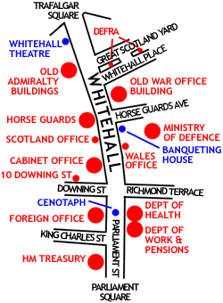
Whitehall showing the major UK Government buildings.
[edit] Government buildings in Whitehall (north to south)
[edit] Other notable buildings in Whitehall
[edit] Bibliography
- Whitehall Through The Centuries by George S Dugdale (Assistant at the London Museum) with black and white reproductions and plans. A foreword by Sir Edward Bridges [1]
[edit] External links
[edit] Gallery
In 1799 many of the sites now occupied by large government buildings were covered with terraced houses and Parliament Street had not been widened.
|
|
- , First published by Phoenix House (London) in 1950 with no ISBN
Wikimedia Commons has media related to:
Coordinates: 51°30'15?N, 0°07'35?W
(Source: Wikipedia) |